The Official website sanctioned by the Huron County Airport Authority, Norwalk, Ohio
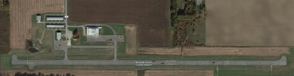
Mailing: P.O. Box 406, Norwalk, OH 44857
Airport Authority Board:Scott Sparks 419-706-2901 or Scott@HuronCountyAirport.co | |
Nick Burch 419-706-5293 or Nick@HuronCountyAirport.co | |
Michael Barefoot 419-656-9629 or Michael@HuronCountyAirport.co |
We have a hanger available for lease. Please contact Scott Sparks for information.
Runway Condition is Good
We recommend parking on the east ramp. Agriculture Spraying may be operating on West Ramp.
All fuel is self service,
Jet A fuel is available, over the wing refueling nozzle only.
100LL is available
Place overnight tiedown payments in an envelope located in the black drop box in the fuel shack.
Please put your registration number and name, so we can verify payments with camera footage.
Rental Car Information:
Courtesy car is available. Please call Scott 419-706-2901 or Jon 419-554-8073 for information
Jimmie Fitzgerald has cars available: 419-541-1670
Huron County Airport Board meeting will be held on the second Monday of every month, 1:30 PM, at the Airport, unless otherwise stated.
This month's Board meeting will be held on June 20, 1:30 PM, at the Airport.
$10.00 for overnight tie down
$20.00 for overnight hangr use (please call Airport Authority Board members)
1st night will be waived with the purchase of fuel
$25.00 for overnight tie down for Jets
$50.00 for overnight hanger use (please call Airport Authority Board members)
Lock Box inside Fuel Building
Honor System with Lock Box (Adopted 08/10/2015)
Airport Hanger Rents -
10% Discount for multiple planes (first plane remains full price)
Updates on progress at airport / grant / repairs, etc. (Updated 07/22/2015)
FAA Identifier: |
5A1 |
Lat/Long: |
41-14-41.1570N / 082-33-04.4180W |
Elevation: |
852 ft. / 259.7 m (surveyed) |
Variation: |
06W (1995) |
From city: |
3 miles E of NORWALK, OH |
Time zone: |
UTC -4 (UTC -5 during Standard
Time) |
Zip code: |
44857 |
Airport use: |
Open to the public |
Sectional chart: |
DETROIT |
Control tower: |
no |
ARTCC: |
CLEVELAND CENTER |
FSS: |
CLEVELAND FLIGHT SERVICE STATION |
NOTAMs facility: |
CLE (NOTAM-D service available) |
Wind indicator: |
yes |
Segmented circle: |
no |
Lights: |
ACTVT MIRL RY 10/28 - CTAF. |
Beacon: |
white-green (lighted land airport) |
CTAF/UNICOM: |
122.8 |
MANSFIELD APPROACH: |
124.2 [0600-2300] |
MANSFIELD DEPARTURE: |
124.2 [0600-2300] |
WX ASOS at LPR (18 nm E): |
121.425 (440-323-7088
|
VOR radial/distance |
|
VOR name |
|
Freq |
|
Var |
SKYr162/12.3 |
SANDUSKY VOR/DME |
109.20 |
04W |
|||
DJBr254/18.8 |
DRYER VOR/DME |
113.60 |
05W |
|||
MFDr008/22.6 |
MANSFIELD VORTAC |
108.80 |
03W |
NDB name |
|
Hdg/Dist |
|
Freq |
|
Var |
|
ID |
|
328/21.6 |
329 |
07W |
AAU |
.- .- ..- |
|||||
146/21.8 |
423 |
07W |
PCW |
.--. -.-. .-- |
|||||
078/31.3 |
269 |
05W |
TII |
- .. .. |
|||||
090/38.3 |
379 |
05W |
FZI |
..-. --.. .. |
Fuel available: |
100LL |
Parking: |
Hangars and Tiedowns |
Airframe service: |
MAJOR |
Powerplant service: |
MAJOR |
Dimensions: |
4210 x 75 ft. / 1283 x 23 m |
||
Surface: |
asphalt, in good condition |
||
Runway edge lights: |
medium intensity |
||
RUNWAY 10 |
|
RUNWAY 28 |
|
Latitude: |
41-14.686883N |
41-14.684633N |
|
Longitude: |
082-33.532583W |
082-32.614200W |
|
Elevation: |
834.4 ft. |
852.0 ft. |
|
Gradient: |
0.2% |
0.2% |
|
Traffic pattern: |
left |
left |
|
Runway heading: |
096 magnetic, 090 true |
276 magnetic, 270 true |
|
Displaced threshold: |
240 ft. |
668 ft. |
|
Markings: |
basic, in good condition |
nonprecision, in good condition |
|
Runway end identifier lights: |
no |
no |
|
Touchdown point: |
yes, no lights |
yes, no lights |
|
Obstructions: |
90 ft. trees, 201 ft. from runway,
251 ft. right of centerline |
17 ft. road, 201 ft. from runway,
242 ft. left of centerline |
Ownership: |
Publicly-owned |
Owner: |
HURON COUNTY COMMISSIONERS |
|
|
|
|
|
- |
DRAG STRIP AT E END OF RWY
RUNNING NORTH-SOUTH. |
NOTE: All procedures below are
presented as PDF files. If you need a reader for these files,
you should
download the free Adobe Reader.
NOT FOR NAVIGATION.
Please procure official charts for flight.
FAA instrument
procedures published for use between 25 June 2015 at 0901Z and
23 July 2015 at 0900Z.
|
||
RNAV (GPS) RWY 28 |
|
|
NOTE: Special Take-Off
Minimums/Departure Procedures apply |
|
download (164KB) |
Other nearby airports with instrument
procedures:
8G1
- Willard Airport (15 nm SW)
KLPR - Lorain
County Regional Airport (18 nm E)
1G1 - Elyria Airport
(21 nm E)
KPCW -
Erie-Ottawa International Airport (22 nm NW)
S24 - Sandusky
County Regional Airport (22 nm W)